
Christo Vosloo
Graduate School of Architecture University of Johannesburg,Luvuko Mqaqa
Graduate School of Architecture University of JohannesburgThe development and planning implemented during various historical periods before and during apartheid have resulted in many former ‘Bantustan’ and South African cities being fractured, incoherent, and thus characterised by an absence of a fair economy and effective spatial and infrastructure development. This situation thwarts economic growth and poverty relief. To highlight the issues and context of “Bantustan” cities, one of them, Mthatha, will be used as a case study. Using literature review methodology, four distinct historical periods will be examined to understand the city’s current situation. The periods are the Pre-colonial period, the Colonial period (1816-1910), the Apartheid and the post-apartheid period (1994 to present). The planning patterns resulted in many problems that thwarted efforts at economic uplift within these cities. It will be shown that a strategy is required that will reverse the planning legacies of colonialism and apartheid by encouraging local aspirations, enabling integration, and stimulating urban opportunity and, thereby, economic enablement.
A cursory examination of the map of Mthatha (refer to Figure 1) will show that the city is fractured, not only because of the planning practices followed but also by the winding curves of the Mthatha and Cicra rivers that cut through it. A closer inspection will reveal that there are only a limited number of bridges spanning across these rivers to connect the disparate parts. Another striking feature is the lack of public spaces and a cohesive public spatial system.
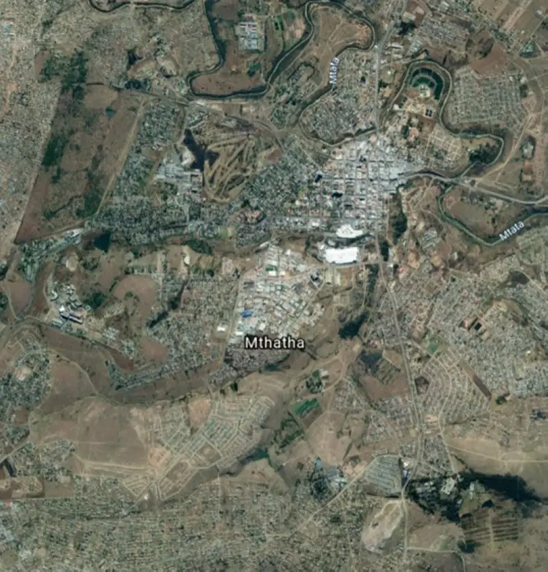
Figure 1. Mthatha General Area. Source: Google Earth (2020)
Looking at the city’s layout, it becomes clear that the planning ignores the needs of the inhabitants. The fact that most inhabitants are poor, and hence, that in the absence of a cheap, effective public transport system, and pedestrian movement should be prioritised, and socio-economic facilities decentralised and not centralised (as they currently are) so that they could be easily accessible. The problem that is Mthatha is exacerbated by the fact that the areas surrounding the city are controlled by traditional leaders and not the local authority with land allocated to people by these leaders without any property rights, planning or servicing, resulting in large shack communities that are not under the jurisdiction of the Mthatha City Council. The city is a disabling environment.
This paper will investigate how this came to be, based on a literature review. The form of the city is one of the factors of the physical and socio-economic problems and lack of opportunity that plague the city. The aim is to gain a comprehensive understanding of the problem represented by Mthatha in order to suggest how this disadvantage can be transformed.
The study will firstly identify the features which Mthatha has inherited from the colonial and apartheid planners, the consequences of these top-down planning strategies and why an alternative strategy, one that is ‘bottom-up’ and focuses on the needs of the people, present the only viable way forward.
Mthatha lies in “the flat country” between the Mbashe and Mthatha rivers (Hammond-Tooke, 1957, p.34). The area is strategically positioned between two great rivers, the Mbashe to the southwest and Mthatha to the northeast, ideal for the optimum exploitation of resources, including the surrounding villages, fields, and water resources. Thus, a developing micro economy existed, which may be why the colonials chose to settle in this area.
During the pre-colonial period, life was characterised by farming and pastoral activities (Hammond-Tooke, 1974, p.90-138). Spatial development was governed by a distinct pattern of settlement developed to meet the common human need for political safety and control of available resources (Hammond-Tooke, 1974, p. 86). The typical settlement pattern for all the Nguni tribes of the Transkei and Ciskei was villages. Saunders and Derricourt (1974, p. 70) tell that a village comprised many kraals and occupied an area of about 18 square kilometres. Villages were grouped in tribal clusters. In the clusters, villages were spaced roughly eight kilometres apart (Van de Kemp in Saunders and Derricourt, 1974, p. 70).
In this way, the pre-colonial settlement pattern of “Thembuland” (as the area was known) enabled the entire community to thrive by allowing people to use the large open pastures around villages. The kraals, villages and clusters developed through organic growth. Hammond-Tooke (1974, p. 90) describes how transportation was mainly on foot and villages were linked by trade routes made by travellers. Saunders and Derricourt (1974, p. 70) agree and assert that “paths or recognised routes seem to have existed between cluster core areas and between villages and clan core areas”. Thus, this type of settlement was decentralised, relatively dense, and fostered various human socio-economic activities such as trading of natural resources and sharing communal land (public spaces) between the villages, resulting in ease of access to resources and promotion of travel by foot.
Mthatha was initially established as a military outpost for British forces in 1882 and founded in 1883 as a rural settlement and service centre in the British Colonial Era (Lombaard, 2010, p. 12). According to The Republic of Transkei (1976, p. 72), the first European farmers settled on the South Bank of the Mthatha River in 1869, with the permission of Ngangelizwe (Thembu Chief), who intended to form a European buffer against his ‘enemy’ Nqwiliso (Mpondo Chief). In 1872 the Mpondo chief followed suit by forming a buffer settlement of European farmers on the North bank, where the suburb of Norwood now stands. These “buffer strips” were meant to discourage the continuous raids that occurred between the tribes.
According to The Republic of Transkei (1976, p. 72), a group of European men, described as “pioneers”, requested the Colonial secretary to select and survey a township in Thembuland. As a consequence, Thembuland came under British rule in 1876. By 1879 Mthatha had been surveyed, and soon Mthatha grew into a village and then a town of importance. With “the annexation of Pondoland in 1894”, Mthatha’s territory expanded to include both Thembuland and Mpondoland. The annexation saw the construction of the Mthatha River Bridge linking the Cape to Natal. “By 1899, Mthatha had become the distributing centre of a vast area” and was “established as the headquarters of the Government, the Military and the Church” (Republic of Transkei, 1976, p. 72).
The military planners of the settlement used the surrounding settler farms as protection for the military post and rural town against the surrounding Thembu and Mpondo tribes (refer to Figure 2). These were the initial steps towards social organisation using separationist methods. It also meant that the separatist DNA had been laid out in the area.
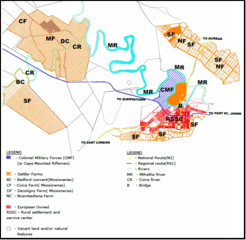
Figure 2. Mthatha, rural settlement and service centre 1876-1910, (By authors based on research data: 2017)
Brockett (1998, p.121) holds that the British settlements typically had a grid layout, with small erven or stands and concentrated commercial areas. Buildings, housing administrative facilities and/ or the cricket ground were in the centre, while churches and their associated graveyards were relegated to the outskirts of town.
Morris in Steyn (2014, p. 13) asserts that these were “planned towns”, and settlers within these towns were granted “a house plot…together with farming land within the vicinity and other economic privileges”. This pattern was followed in the layout of the central part of Mthatha. Notably absent was any provision for the local population in the central area: They were relegated to the surrounding areas.
4.1 The Apartheid City
The Apartheid period can be divided into two planning periods; the first is the Segregation Period (1910-1948). This period was implemented as part of British rule under the government of the Union of South Africa. The second is ‘Grand Apartheid’ (1948-1994), which followed the National Party’s rise to power in 1948.
4.1.1 Segregation
The Segregation Period was driven by the Land Acts of 1913 and 1936. The acts were accompanied by various other policies for urban areas, such as the Natives (Urban Areas) Act (1923) as well as the Natives (Urban Areas) Consolidation Act (1945) (Donaldson & Krige 2000, p.3). The national government limited the access of Africans to civil amenities by implementing the Separate Amenities Act of 195 (Johnson, 1994, p. 78-9).
According to Donaldson & Krige (2000, p. 3), the urban areas acts meant more stringent influx control regulations, the fordable removal of unwanted black people, relocating them to the reserve areas set aside for them and the imposition of temporarily status to those that were allowed to remain. Thus, it resulted in the black townships’ relocations or locations to the outskirts and outside the town for the same reasons of the Colonial City period. Nonetheless, these policies were not fully implemented until the National Party’s rise to power in 1948.
Johnson (1994, p. 78) believes that “apartheid in Umtata [Mthatha] was the same as elsewhere in South Africa. Furthermore, the Group Areas Act meant that the Mthatha Town Planning Scheme had to follow the same segregationist ideology with the CBD area designated for Europeans, Norwood for coloureds and Ngangalizwe being established as a township for black people (refer to Figure 3).
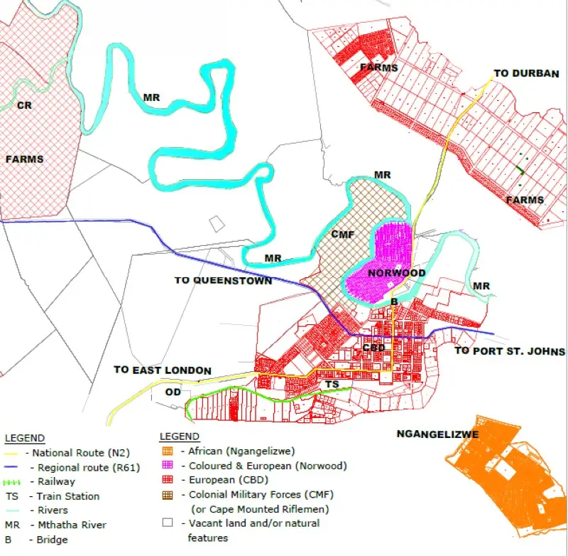
Figure 3. Apartheid 1910-1948, Mthatha (By author based on research data)
Although still at an elementary level compared to “the model apartheid city”, Mthatha was subject to the initial stages of apartheid planning. The following apartheid principles are evident in Figure 6:
4.1.2 Grand Apartheid
The second period of apartheid (1948-1994) saw the “rise of a nationwide system to control and regulate the urbanisation of black South Africans” (Harrison, Todes & Watson, 2008, p. 22) and the rise of what Donaldson & Krige (2000: 3) refers to as “The Ethnic City”. This period was mainly characterised by introducing the Bantustan system, whereby the Transkei was constituted as a self-governing state on 30 May 1963 (Johnson, 1994, p. 138). This was consequently followed by Transkei’s ‘independence’ from the South African state on 26 October 1976 (Johnson, 1994, p. 87) and the resultant capital status of the city of Mthatha. The new Transkei government supported the NP’s apartheid system and administered laws such as the Illegal Squatter Act that ensured that the growth of unlawful tenure was kept to a minimum (Siyongwana, 2005, p. 208).
According to Siyongwana (2005, p. 200), Mthatha was regarded as the most successful ethnic city and the Transkei best represented the Apartheid government’s policy of separate development. During the apartheid planning period, segregation took on a new face termed “Grand Apartheid”, which entailed the establishment of homelands for the different ethnic groups (Donaldson & Krige, 2000, p. 3). This ideology resonated with the ideals of the modern movement and by the “British New Town Movement” (Brocket, 1996, p. 175): Scott (1998, p. 103) holds that these “urban and regional spatial models of [the] UK and Europe” fitted perfectly with the apartheid vision of “regional decentralisation and constrained urban growth”. At the city level, it translated into “slum clearance, urban renewal, new township development, and the restructuring of cities to improve car mobility” (Taylor in Harrison et al., 2008, p. 205).
Modernist planning principles are evident in the urban form of Mthatha in several ways: Street spaces are designed primarily for vehicles and not to encourage pedestrian traffic, neighbourhood route networks are planned for vehicular mobility and not accessibility for pedestrians. Development densities are low and land use fragmented. As shown in Figure 4, it is out of this construct that planning schemes evolved for cities such as Mthatha, driven by approaches like Le Corbusier’s belief in strict functional separation (Scott, 1998, p. 109).
Between 1963 and 1994, Mthatha benefitted from being the principal administrative and educational capital in the Transkei region, with expansive plans for industrial and expansion projects. According to the Republic of Transkei (1976, p. 69), such projects included the new high-rise administrative block for the Transkeian government, the presidential residence and new suburb of luxury homes for Cabinet Ministers; large extensions to several existing residential areas; a new industrial township designed to attract more industries to Umtata, the new campus at Umtata of the University of Fort Hare headquartered at Alice some 200km away to the south; the KD Matanzima Airport, Transkei’s new international airport; the headquarters of the Transkeian Defence Force; a large new sports stadium; a new large hotel and a new in-service training centre for teachers.
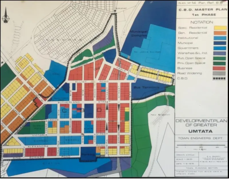
Figure 4. The development plan of Mthatha (Mzamo, 2018,p. 83)
Despite Mthatha acquiring all these useful amenities, these were once again not integrated into the existing public spatial system or what was supposed to be the spatial system. When looking at Figure 4, it is evident that the public open spaces are not adequately integrated into the development plan. Instead, the predominant public open space on the bottom right acts as a buffer strip to Ngangelizwe (see Figure 5) and the government and municipal sites do not provide adequate open public spaces where people can socialise and perhaps even trade.
In this paradigm, group (ethnic) areas supported segregation in towns and cities since separate facilities for health, education and other social services were built in each area. Additionally, separating buffer strips were inserted to enhance group areas’ division. The buffer strips could be human-made elements such as roads, railway lines, industrial zones or natural, for instance, ridges, rivers and undeveloped open spaces.
Donaldson & Krige (2000, p. 3) hold that the policies used to achieve racial segregation since 1950 are characterised by residential and commercial segregation, the relegation of residential areas for ‘non-whites to the periphery and surrounding areas, the amalgamation of residential zones and the removal of ethnic islands, racially integrated sections, slum areas and squatter settlements. Furthermore, black communities were separated ethnically in homelands with the Migrant Labour system introduced to provide labour for the white cities.
Figure 5 shows how functional separation was implemented in the case of Mthatha.
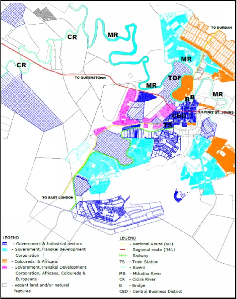
Figure 5. Apartheid 1963-1994, Mthatha (By authors based on research data)
The post-apartheid period brought many changes in the government of Transkei and the development of Mthatha. The city lost its erstwhile status as the ‘capital’ of an ‘independent’ state. The civil service was merged with that of Ciskei and moved to Bisho. The University lost its independence and was merged with other regional institutions to form the Walter Sisulu University.
At the outset of the period, spatial planning had moved from an instrument of control towards an emphasis on strategic spatial planning. Besides, there existed a strong emphasis on participatory and community-based planning (Harrison et al., 2008: 54). Todes informs that the notion of special urban restructuring, compaction and integration featured strongly in official policy (2006, p. 50). However, the primary legislation that impacted Mthatha was the South African Constitution (Act 108 of 1996), section 152(1)(c), which forced municipalities to institute socio-economic and political development of the city (Siyongwana, 2005, p. 208). Unfortunately, in Mthatha, this legislation did not follow the central government’s policy. Instead, a remnant of the failed apartheid form of governance lives on in the new Reconstruction and Development Programme (RDP) housing system of this incoherent town: Todes’ (in Siyongwana, 2005, p. 209) view RDP as a continuation of old developmental paradigms. Thus, what can be observed in Mthatha is the unwitting continuation of apartheid social organisation, which has led to further disintegration, the dilapidation of infrastructure, inadequate waste management, informal trading and slums in the Mthatha CBD.
Harrison et al. (2007, p. 11) point to the failure of post-apartheid planning to transform apartheid cities through integration and development. The marginalisation of the ordinary citizens, especially the African majority, is much more profound, as can be seen in the expanding informal economy and settlements. In Mthatha, the construction of the so-called RDP houses across the city, for instance, in Waterfall Park and Zimbane areas near the city, support the position held by Todes’ (in Siyongwana, 2005, p. 209) that the pattern of segregation continued.
A major challenge confronting the post-apartheid Mthatha’s municipality is the rapid growth of informal settlements and street traders. This situation was exacerbated by the fact that surrounding areas are governed by traditional leaders and hence to different forms of land tenure, which resulted in illegal land grabbing and the emergence of a mixture of formal and informal settlements. A few examples are Slovo Park, Chris Hani Park, and Zamukulungisa (new informal settlements, as shown in Figure 1), which emerged in better-located areas earmarked to be developed for the benefit of the city (Siyongwana, 2006, p. 210-11). Thus, Harrison et al. (2007, p. 11) assert that currently, South African towns and cities have become as much or more spatially divided than they used to be during apartheid. However, this is not due to segregating legislation but due to market forces and increasing economic disparities. South African towns and cities are “increasingly defined by class rather than race”, and the vast majority remains marginalised in the spreading informal.
In Mthatha, the issues discussed above are very much a reality; low-income housing has continued in the “non-white townships”, and informal layout settlements have mushroomed all around the urban edge (refer to Figure 6). The economy is inequitable in that emerging businesses cannot compete with the few but significant, national corporates (Afesis-Corplan, 2011, p. 2).
It is out of the above policies and their implementation that the disabling city form, now evident in Mthatha and other South African cities, the so-called ‘Apartheid Cities’ emerged. According to Dewar (1992, p. 10-17), Hindson, Mabin and Watson (1996, p. 13-14), and Lemon (1991, p. 1), the characteristics of these cities are that they are disjointed and fragmented with the different functional zones and racial areas isolated from each other.
Densities are low, and development spread over large, poorly connected areas. Motorways, open space, railway lines, industrial zones, etc. are used to separate individual areas from each other complicating movement within the city and to economic and social facilities and opportunity-particularly for the poor who often have to travel by foot. Thus, it is a disabling environment: Single function use zoning with no or limited provision for the socio-economic facilities (and opportunity) are the opposite of what is required for development and upliftment.
Most of the facilities offering social and economic opportunity are centralised in the central business areas making it difficult and expensive to reach. A situation worsened because lower-income areas are situated on the periphery furthest away from these facilities. This disabling layout increases time spent and the cost of accessing such facilities for the poorest section of society.
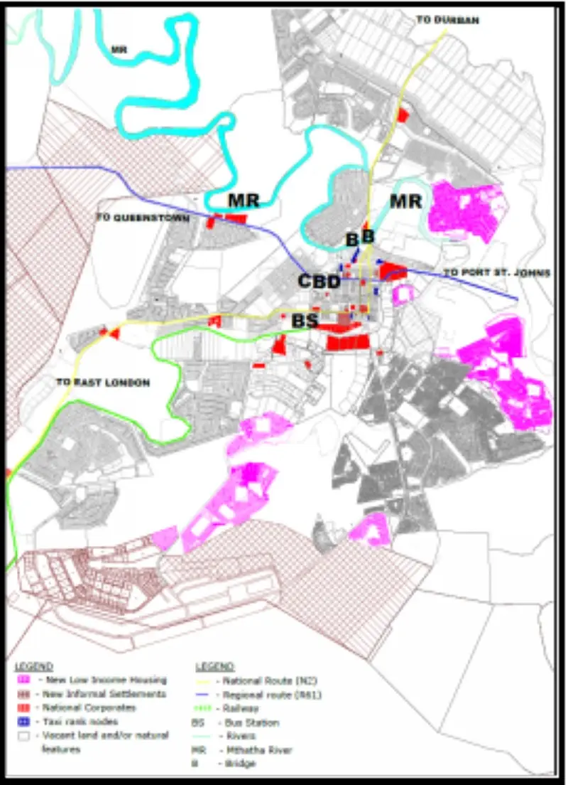
Figure 6. Economic Segregation 1994-Present, Mthatha (By author based on research)
The absence of a positive pedestrian-friendly public spatial network strengthens the disabling nature of the city. Public open space, unsafe, poorly defined, non-cohesive, unstructured, arbitrarily located, becomes no more than non-supportive obstructive spaces. The situation causes the system to absorb money that should have been used to develop more socio-economic facilities and opportunities: An untenable, impoverishing and disabling situation.
Research and the discourse around the restructuring and integration of the South African or apartheid city were prominent in the early 1990s when it became clear that apartheid was nearing its inevitable demise and that democracy and with that, reconstruction of South Africa was imminent. Hence, many of the proposals in this section emanate from that period.
7.2. Interventions that can reverse the current situation
7.2.1. A positive public spatial system
Dewar and Uytenbogaardt believe that improvements to the urban environment require a change of focus; from shelter provision to creating positive urban qualities such as space, place, choice, convenience and opportunity. To them, the real challenge is the creation of settlements that can do more than to allow the variety of intertwined patterns of needs and activities associated with everyday urban life but will enrich society with a diverse array of socio-economic opportunities (1995, p. 8).
A strategy to create an upbeat urban environment should comprise three essential elements: Establishing a quality public spatial system. Public spaces are the places where collective activities and the events that are the essence of urban life take place (Behrens & Watson, 1996, p. 89-104): They can create a feeling of permanence, they order the distribution of urban activities and provide order and structure, thereby providing ‘clarity’ to an area. Furthermore, they create opportunities for collective activity. Dewar and Uytenbogaardt (1995, p. 15-17) concur that “… the art of site making, of planning, is manipulating the elements of structure into a carefully considered [system of] references which order the land.”
Secondly, the public spatial network should be strengthened by incorporating socio-economic facilities. Behrens and Watson (1996, p. v) believe that such a system provides areas for public interaction with enhanced linkages, thereby creating access between the areas.
Thirdly, it can enhance the aesthetic quality of an area. Behrens and Watson (1996, p. 137-140) believe that public spaces can shape enduring reactions to the area. Furthermore, they can be used as part of place-making actions. Dewar and Uytenbogaardt (1995, p. 10) share this view. They hold that precedent shows that the quality of the public spatial environment is essential in positively performing urban environments. Public spaces are the spaces where people interrelate with a city or town and become part of its actions. Furthermore, public spaces are so much more important in the lives of the urban poor because there are often cramped and overcrowded conditions that cannot provide for a household’s needs: Many aspects of their lives are played out in public space. Furthermore, adequately made public spaces provide dignity and a sense of permanence to urban environments. Dewar and Uytenbogaardt (1995, p. 1-20) hold that a clear and positive spatial system can unlock the individual actions that can result in complexity and intensity, the hallmarks of high-quality urban environments. They see urban spaces as places that can give character and flavour to a city.
Fourthly, the diverse movement patterns created by introducing such a clear spatial structure will bring economic potential to areas because it will result in areas of varying intensity, opportunity and diverse activity. A positive spatial system coupled with the freedom to respond to the opportunity it brings will stimulate economic enterprise (Dewar & Uytenbogaardt, 1995, p. 20). They believe that “… it is this pattern that significantly affects the range of opportunities the settlement offers inhabitants”. Thus, a clear and positive spatial system can be seen as a prerequisite for an enabling environment. It is also central to some of the National Housing Forum (NHF)’s proposals for the integration of the fractured form and economies of our cities (I996, p. 127), the creation of a more equitable city and greater efficiency of the money invested in restructuring (1996, p. 145-146).
7.2.2 High-density development
High-density developments hold economic advantages: It becomes cheaper to build roads and other infrastructural provisions (Dewar, 1992, p. 17). They also have an enabling advantage because the higher densities and concentration of users can provide the support levels needed for a successful enterprise (Dewar & Uytenbogaardt, 1995, p. 56). Higher densities also offer considerable environmental advantages such as an improved spatial quality that is easy to read and understand (Behrens & Watson, 1996, p. vi) and the moderation of climatic extremes (Konya l980, p. 39).
7.2.3 Multifunctionality
Multifunctionality is convenient as well as environmentally and economically beneficial. Multifunctionality creates convenience: Inhabitants can have the full range of socio-economic facilities within walking distance. It allows equal access because all citizens can benefit from the full range of socio-economic facilities. A range of land uses within a relatively small area is required for high levels of diversity, complexity and intensity; a positive public spatial environment depends on a range of socio-economic facilities and institutions. Its inherent variety can result in locational diversity. Also, socio-economic facilities placed nearby can be used to integrate elements in the urban landscape, necessary for a fractured city (Dewar & Uytenbogaardt, 1995, p. 8-59; Behrens & Watson, l996, p. vi). Multifunctionality can also provide specific economic advantages because it will reduce travel distances and travel costs, while the presence of critical social facilities can stimulate economic potential. Dewar and Uytenbogaardt see this type of layout as “…a hallmark of enabling environments” (1995, p. 59).
These proposals are supported by the African Development Bank (cited by Olowu, 2018, p. 60) who propose upgrading informal settlements by providing infrastructure such as education and health care facilities and services, specifically targeted at marginalised groups in the community. Combine this with diversified economic opportunities and activities by creating new business and manufacturing nodes to benefit all citizens.
This paper has shown how years of ‘top-down’ planning forced an urban form onto the people of Mthatha. ‘Top-down’ planning was done with the ultimate aim of achieving specific political aims without placing the socio-economic needs and ambitions of the inhabitants first. The result is a severely disabling city where poverty and disadvantage are commonplace.
The legacy of this urban form will continue for many generations unless drastic action to address these disabling constituents is implemented. Sadly, the democratic period that followed apartheid saw the city lose its capital status with a concomitant loss of economic opportunity. Equally disappointing is the fact that despite many authors pointing to the disadvantage of this low-density, functionally separated style of development, it, like the ‘top-down’ planning approach, remains the management paradigm of the city fathers and the mindset of many ordinary people.
Dysfunctionality remains- the area last provided a supportive and enabling environment before the arrival of the colonial powers. That situation was the result of ‘bottom-up’ people-centred development. For the city to again achieve this status and become an enabling environment, the city should be reconfigured by involving all constituents to address the concerns and ideals established and initiated through a people-centred, radically democratic and ‘bottom-up’ process.
This paper has been presented at the Conference “AGORA CAUMME 2020 – Mediterranean: Between Expansion and Regeneration” and selected by the Conference Scientific Committee to be published in the SPACE International Journal of Space Studies in Architecture and Urban Design. Peer review under the responsibility of the scientific committee of AGORA CAUMME 2020.
Afesis-Corplan. (2011). A sustainable development plan for the urban functional areas of the King Sabata Dalindyebo Municipality, Mthatha and Mqanduli. Retrieved 2011, from http://www.afesis.org.za/local-economic-development/local-economic-development-reports/52-sustainable-development-plan-for-the-ksd-functional -urban-areas.html
Behrens, R & Watson, V. (1997). Making urban places: Principles and guidelines for layout planning. Cape Town: UCT Press. ISBN: 978 0 7992 1650 9
Brockett, L. (1996). The history of planning South African new towns: political influences and social principles adopted. New Contree Journal 43: 109-127
Brockett, L. (1998). The imperial imprint: British colonial towns. New Contree Journal 40: 160-179 ISSN 0379-9867
Dewar, D (1992). South African cities: a framework for intervention. Architecture SA 5(6): 16-18.
Dewar, D & Uytenbogaardt, R. (1995). Creating vibrant urban places to live: a primer. Cape Town: Newco.
Donaldson, R & Krige, S. (2000). Dynamics and inertia of the post-apartheid city. [O]. Available: https://www.impulscentrum.be/south_africa/mod3_city/rechts.asp Accessed 22 September 2018.
Google Earth. [S.a]. Mthatha Map. Retrieved 2020 from, https://earth.app.goo.gl/?apn=com.google.earth&isi=293622097&ius=googleearth&link=https%3a%2f%2fearth.google.com%2fweb%2f%40-31.57962385,28.78309927,664.52523684a,12223.06265946d,35y,360h,0t,0r%2fdata%3dCgAoBA
Hammond-Tooke, WD. (1956). The tribes of Umtata district. Pretoria: Government Printers.
Harrison, P, Todes, A & Watson, V. (2008). Planning and transformation, learning from the post-apartheid experience. London: Routledge. DOI: https://doi.org/10.1111/j.1468-2427.2009.00850_9.x
Hindson, D, Mabin, A & Watson, V. (1992). Restructuring the built environment: Phase 1 report to Working Group 5, National Housing Forum, in
Restructuring the built environment. Booklet 4, edited by K Brugge and N Maleka. Johannesburg: National Housing Forum.
Johnson, WR. (1994). Dismantling Apartheid: A South African town in transition. London: Cornell University Press. ISBN13: 9780801499920
Konya, A. (1980). Design primer for hot climates. London: The Architectural Press. ISBN9781483141084-003
Lemon, A (ed). (1991). Homes apart: South Africa’s segregated cities. Cape Town: David Philip. ISBN 0253333210
Lombaard, L. (2010). Mthatha case study, in DBSA’s Sustainable Communities Programme. Johannesburg: Development Bank of Southern Africa.
Mzamo, B. (2018). Assessing the relationship between Urban Blight and City Attractiveness: The Case of Mthatha CBD. MTRP dissertation, University of KwaZulu Natal, Durban.
National Housing Forum. (1996). Booklet 4: Restructuring the built environment, edited by K Brugge and N Maleka. Johannesburg: The National Housing Forum.
The Republic of Transkei.(1976). Mthtatha: The Republic of Transkei Olowu, D. (2018). African urbanization and democratization: Public policy, planning and public administration dilemmas, in The Routledge companion to planning in the global South, edited by G Bhan, S Srinivas and V Watson. London: Routledge:59-69. ISBN 9781138094130
Saunders, C & Derricourt, R. (1974). Beyond the Cape frontier: studies in the Transkei and Ciskei history. London: Longman Group Ltd.
Scott, JC. (1998). Seeing like a state: How certain schemes to improve the human condition have failed. New York: Cornell University Press. ISBN: 9780300078152
Siyongwana, PQ. (1990). Residential transformation in Umtata since 1976. Master’s dissertation, University of Port Elizabeth, Port Elizabeth.
Steyn, GS. (2014). 1000 years of urbanism in southern Africa: an integrated overview. Paper presented at the XXV International Union of Architects (UIA) World Congress, Durban, 2014, 4-6 August 2014.
Todes, A. (2006). Urban spatial policy in Democracy and Delivery, in Urban policy in South Africa, edited by R Tomlinson and J du Toit. Cape Town: HSRC Press. ISBN 0796921563
No potential conflict of interest was reported by the author(s).
Christo Vosloo
Luvuko Mqaqa
Sign in to continue
Not a member yet? Sign up now

Administrative Assistant
Deniz Bol is the Administrative Assistant at SPACE Studies, where she supports the day-to-day operations and contributes to the smooth functioning of the organization. Alongside her administrative role, Deniz is an artist with a passion for creative expression. She is currently pursuing her studies at the University of the Arts London (UAL), where she continues to develop her artistic practice. Her organizational skills, paired with her artistic background, make her a valuable asset to the SPACE Studies team, helping bridge the worlds of administration and creativity.
E-mail: denizbol@spacestudies.co.uk

Digital Marketing Consultant
Murat Oktay is the Digital Marketing Consultant at SPACE Studies, where he provides strategic guidance to enhance our digital presence and community engagement. With a keen eye for digital marketing trends and best practices, Murat plays a key role in refining our content strategy, expanding our online reach, and connecting with a wider audience. His expertise in digital tools and innovative marketing techniques aligns with SPACE Studies’ mission as a social enterprise, ensuring that our campaigns are impactful and resonate with our commitment to social responsibility in architecture and design. Outside his work with SPACE Studies, Murat stays at the forefront of digital marketing advancements, continually exploring new tools and sharing his insights with peers.
E-mail: muratoktay@spacestudies.co.uk

Marketing Manager
Santa Noella Matabaro is the Marketing Manager of SPACE Studies, bringing her expertise in strategic planning, community engagement, and relationship-building to the organization’s mission as a social enterprise. With a background in Politics & Law from the University of Kent, Santa combines analytical insights with a creative approach to advancing SPACE Studies’ vision of fostering interdisciplinary dialogue in architecture, design, and urban planning. In her role, she develops targeted campaigns and strategic partnerships, building brand presence and fostering meaningful connections with the community. Santa’s collaborative and people-centered approach enhances SPACE Studies’ impact, aligning with its commitment to social responsibility and innovation in the built environment.

Academic Content Coordinator
Betul Uckan is an architect and dedicated academic with a background in both architectural practice and research. She holds a Master of Science in Architectural Design and a Bachelor’s degree in Architecture from Istanbul Technical University, where she cultivated her interests in architectural theory and design. Betul has gained experience as a research assistant in various universities, contributing to design studios and foundational courses. She has also worked in the field as an architect with projects focused on design, modeling, and construction, and has been involved in notable projects, including Maltepe Piazza and Emaar Square in Istanbul. With her expertise spanning both digital and material architecture, Betul brings a dynamic, interdisciplinary approach to her role as the Academic Programme Coordinator.
E-mail: betuluckan@spacestudies.co.uk
Senior Researcher & Managing Editor
Arghavan Pournaderi is a senior researcher in the field of architectural conservation and restoration, with an academic foundation in architecture and specialized expertise in historic sites and buildings. Completing her PhD at the Art University of Isfahan, Iran, in 2019, her research has contributed to the understanding of Iran’s architectural heritage, with a focus on Isfahan’s urban and architectural evolution during the Safavid period. In addition to her extensive research, Dr. Pournaderi has held academic positions at various institutions in Isfahan, teaching at both undergraduate and graduate levels. Her work extends beyond academia as she contributes to SPACE Studies as Senior Researcher & Managing Editor, where she oversees scholarly initiatives that foster deeper interdisciplinary dialogue in architecture and heritage conservation.

Senior Researcher & Educational Consultant
Gregory Cowan is a Senior Researcher and Educational Consultant at SPACE Studies, where he leads initiatives that bridge academic research and practical application in architecture and urban design. He contributes his extensive experience to mentoring postgraduate students, designing educational workshops, and guiding community-focused projects. Gregory is also a freelance academic at the University of Wales Trinity St David and the University of Westminster, and founder of The Architects Coach. His expertise spans architectural workspace analysis, professional development, and positive intelligence coaching.
E-mail: gregorycowan@spacestudies.co.uk

Senior Researcher
Alison Hand is a Senior Researcher at SPACE Studies. She is a painter and writer with an MA in Painting from the Royal College of Art. Alison’s work focuses on creating absurd, unstable heterotopic spaces and dialogues with painting history. She is currently the Artist in Residence for King’s College London Philosophy Department on the Dreams and Wakeful Consciousness Research Project, exploring themes of time and simultaneity in new work. Alison has received numerous awards for her painting and is currently working with Bloomsbury Publishers on a major essay on Drawing in Contemporary Art. She is also the BA Fine Art Programme Leader at Art Academy London and co-director of Cement Arts. Her role at SPACE Studies involves leading research projects, mentoring junior researchers, and contributing to our artistic and academic initiatives.
E-mail: alisonhand@spacestudies.co.uk

Senior Researcher
Julian Wild is a Senior Researcher at SPACE Studies and the Sculpture Program Leader at The Art Academy London. With over 30 years of experience in creating and exhibiting sculptures, Julian has worked with high-profile clients such as Cate Blanchett and the University of Oxford. A fellow and former vice president (2015-2019) of the Royal Society of Sculptors, his work has been featured at venues like Modern Art Oxford and Chatsworth House. At SPACE Studies, Julian leads research projects, mentors junior team members, and conducts workshops that blend art and urban studies. In his free time, he enjoys attending academic conferences and crafting new sculptures.
E-mail: julianwild@spacestudies.co.uk

Director of Publications & Senior Researcher
Elif Suyuk Makakli (Associative Professor) earned her PhD in Architecture from the Vienna University of Technology, where she studied the impact of technology on architecture under Prof. William Alsop. With extensive experience in architectural practice in Istanbul and Vienna, she is now an Associate Professor at FMV Isik University, focusing on design education and technology. At SPACE Studies, Elif serves as both the Head of Publications and Senior Researcher, guiding scholarly content and contributing to research initiatives. She is dedicated to mentoring and fostering design innovation.
E-mail: elifsmakakli@spacestudies.co.uk

Director of Research
Sanaz Shobeiri is an architect, urban designer, and landscape urbanist, currently a postdoctoral researcher in the Department of Planning at Queen’s University Belfast. Her research focuses on age-gender inclusiveness and the interplay of architectural, historical, political, and sociocultural dimensions in urban spaces, exemplified by her project on city centres in Belfast and Tehran. Sanaz holds a PhD in Urban Planning from the University of Tehran and has a robust portfolio in sustainability and urban theory. As Head of Research at SPACE Studies, she leads innovative research initiatives, fostering collaboration and academic excellence. In her free time, Sanaz enjoys exploring urban landscapes and supporting community development.
E-mail: sanazshobeiri@spacestudies.co.uk

Creative Director
Selin Gulce Sozmen is the Creative Director at SPACE Studies, where she leads the artistic vision and design strategy for the organisation. With a background in graphic design and visual arts, Selin has been instrumental in creating visually captivating books, journals, and event posters. Her role extends to developing and coordinating workshops and creative projects, ensuring that all visual materials meet the highest standards of quality and innovation. Selin’s dedication to creativity and excellence drives the visual and creative direction of SPACE Studies, making her an essential part of the team.
E-mail: selinsozmen@spacestudies.co.uk

Founder & Executive Director
Pinar Engincan is the Founder and Executive Director of SPACE Studies, an innovative social enterprise focused on fostering interdisciplinary dialogue and education in architecture and urban design. With extensive experience as a lecturer and researcher, Pınar holds a PhD in Architecture and has led numerous academic initiatives. Her career includes curriculum development, international collaborations, and research on housing and urban policies. Passionate about bridging academia and community, she champions accessible education and consultancy services, empowering individuals to shape the built environment.
E-mail: pengincan@spacestudies.co.uk